Regional airline pilots soon should be able to tap into a more detailed and real-time picture of weather problems than what they have now, even better than what pilots for some larger carriers use, thanks to technology supported by the National Aeronautics and Space Administration (NASA).
For a long time, there’s been significant interest in getting better, up-to-the-minute weather data to pilots, says Taumi Daniels of NASA’s Langley Research Center, who served as the agency’s project manager for a year-long demonstration of AirDat LLC‘s Tropospheric Airborne Meteorological Data Reporting (TAMDAR) system in the Great Lakes region. Poor weather is a contributing factor in about 30 percent of all accidents, he adds.
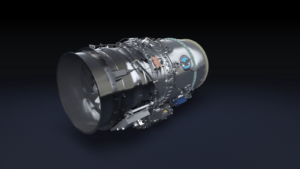
AirDat technicians installed TAMDAR sensors, each about the size of a first-generation home camcorder, aboard approximately 60 Saab 340 airplanes belonging to Mesaba Airlines (operating as Northwest Airlines [NWACQ.PK]). On every run, each airplane takes soundings of surrounding atmospheric conditions, and transmits them back to a weather forecasting station (one sounding gets several types of weather data). Although NASA’s demonstration ended in January, Mesaba is still using the equipment.
The Federal Aviation Administration (FAA) and the National Oceanographic and Atmospheric Administration (NOAA) also were partners in the demonstration with Mesaba.
By comparing TAMDAR with some of today’s systems of atmospheric readings, it’s readily apparent what some of TAMDAR’s advantages are. For example, under the current national network of nearly 70 weather balloons, each balloon takes two soundings a day.
But if nearly every regional and commuter aircraft in the country took soundings every two minutes of flight time, as TAMDAR does, that would be a lot of new data. It also would mean far less interpolating for weather forecasters trying to fill in the gaps on weather maps.
For those 70 weather balloons, there are at most 140 daily soundings nationally, AirDat’s vice president of operations, Rick Ferguson, tells Air Safety Week. But with Mesaba using TAMDAR departing from about 75 airports in the Great Lakes region, there’s about 800 soundings on a typical day.
Air Safety Week asked Ferguson if there would be temporary data drop-outs as readings of severe weather come in from certain routes, which are then avoided by pilots seeking clearer routes. Ferguson agreed that’s a possible scenario, at least initially. But “once we understand the behavior patterns of pilots, we can adjust our ground-based processing systems.”
TAMDAR “was conceived to overcome some of the limitations of existing atmospheric sounding technologies, including radiosondes and … MDCRS,” AirDat says. TAMDAR focuses on lower altitudes in the troposphere that most larger commercial airlines fly over. It also adds to the usual data on temperature, pressure, and winds measurements provided by the Meteorological Data Collection and Reporting System (MDCRS), with additional data on humidity, icing and turbulence, AirDat says.
Also, neither Ferguson nor Daniels is aware of a competing system for TAMDAR in any stage of development.
For now, the TAMDAR data is interpolated for various on-screen presentations, which are seen by dispatchers and reported to pilots, Ferguson says. Someday soon, pilots may be able to see the same information via an intranet on their laptop computers.
Overall, TAMDAR’s “biggest advantage” is that data comes “from locations where we’ve never had data before,” says Rich Mamrosh, a National Weather Service (NWS) meteorologist based in Wisconsin who is well versed in TAMDAR. For Wisconsin, until recently, forecasters had to rely on just three weather balloons. There’s one balloon that takes soundings twice a day in Green Bay, another in International Falls, Minn., and a third in Minneapolis. But under the new system, there’s about a dozen airports within the triangle formed by those three cities that are now connected by TAMDAR-equipped Mesaba aircraft.
At NOAA’s Aviation Weather Center in Kansas City, Mo., forecasters issue regular weather advisories and warnings to pilots around the country. Depending on when and where the balloons are, and erring on the side of caution, these messages have to be fairly broad, Mamrosh explains to Air Safety Week. Information may have to be extrapolated across four to five states.
Meanwhile, MDCRS is limited to the seven commercial airlines that have it aboard their planes, and it focuses mostly on wind and temperature data, NASA’s Daniels adds. It also just focuses on the major hubs.
“NASA considers [TAMDAR] a major success,” he adds. There has been a reduction in error for temperature forecasting of 20 percent. For humidity and winds, the figure is 10 percent. “These are very significant results in numerical forecasting,” Daniels insists. Also, the real-time observations from TAMDAR greatly improve existing weather products that map out turbulence and icing conditions.
NOAA says Mesaba was chosen because of its large prop-jet fleet, which flies in an area with “many meteorological phenomenon,” and flies to and from destinations that coincide with NWS radiosonde locations, thus allowing a comparison of TAMDAR to radiosondes. The Saab 340, in particular, was chosen because it flies shorter flights at lower altitudes than most regional aircraft.
Meanwhile, Bill Poerstel, Mesaba’s vice president of flight and technical operations, calls the demonstration a “successful partnership,” which the carrier also might choose to expand.
AirDat recently inked a deal to start installing its TAMDAR sensors on Horizon Air‘s planes.
>>Contacts: Rick Ferguson, AirDat, (919) 653-4351, Taumi Daniels, NASA, (757) 864-4659, [email protected]; Rich Mamrosh or Gene Brusky, NWS, (920) 497-8771, [email protected] or [email protected]; Elizabeth Costello, Mesaba, (651) 367-5264<<