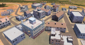
KISSIMMEE, Fla.—The Army recently codified its operational requirements for a worldwide 3D modeling capability that it already uses in training systems, and next up will be consideration by the Joint Staff and potential funding, the acting head of the Army’s Geospatial Center said on Tuesday.

Army Requirements Oversight Council (AROC) approval of the One World Terrain (OWT) software initial capabilities document will let the services build “3D meshes” using any sensor—ground, air, and space—“with some level of attribution,” Dan Visone, acting director of the center, said at the annual GEOINT Symposium near Orlando.

Visone described the resulting capabilities from the OWT 3D imagery models as a “living digital twin that we can continually update.”

The Army already uses OWT to provide imagery for its Synthetic Training Environment (STE), which brings together live, virtual, and constructive training environments into a single STE for all its personnel. Maxar is the prime contractor for OWT.

If real terrain can be used on training systems it can also be used in operational systems, “so this is train as you fight,” Visone told

Defense Daily. The OWT requirement will be for operational and training systems, he said.

The Army is building a geospatial foundation to create a common operating picture but has never had “true 3D data,” Visone said. The current “standard and shareable geospatial foundation” is built on 2D and 2.5D data to provide maps of satellite imagery, elevation, and terrain feature data, he said.

“So, the belief is, we will build one 3D foundation for everybody. And then the training community will take it to get it into their mission command systems and intel systems,” Visone said.

The OWT model is being built to open standards with a goal to encourage industry to build to these standards too, which will open the capability to be used across the services, he said.

Once the OWT operational 3D requirement goes through the Joint Staff’s Requirements Oversight Council, Visone expects the National Geospatial-Intelligence Agency to be a major player providing strategic foundational data, and the Army the Marine Corps providing tactical updates.

Two additional geospatial requirements are working their way through the AROC process, Visone told attendees. One is for next-generation requirements for geospatial engineers and is the Army Integrated Geospatial Enterprise Capability that will replace 20-year-old requirements, he said.

The next-generation requirements will be enterprise oriented for all domains, and leverage artificial intelligence and machine learning to constantly update the foundation, Visone said.

The third requirement is Multi-Domain Intelligence Foundation, which involves support for GEOINT modernization, he said.