KISSIMMEE, Fla.—Combatant commanders and the warfighters they employ need instant access to warning and targeting data without the delays inherent in sorting that information out in distant headquarters organizations, the commander of U.S. Space Operations Command said on Monday.

That geospatial intelligence (GEOINT) data is being provided at the scale and relevancy to make a difference on the battlefield, the head of the National Geospatial Intelligence Agency (NGA) also said on Monday.

“For anyone who suggests we’re not moving as rapidly as possible in our actions and our products, let me be clear,” NGA Director Vice Adm. Frank Whitworth said at the annual GEOINT Conference here. “That’s a complete myth.”

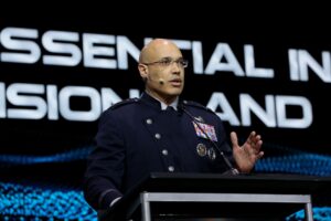
Whitworth’s keynote address was preceded by Space Force Lt. Gen. David Miller, the Space Operations chief, who told the audience that the lesson from Iran’s April 13 strike against Israel using more than 300 drones, cruise, and ballistic missiles, is that a Joint Forces Commander needs to task and then retask assets as a “battle unfolds,” and at the same time get targeting and other information to warfighters and other stakeholders.

“The battlespace of the future requires a few key things and those things are the lessons that I spoke to you about that we learned in the past,” Miller said. “One of them is get the Joint Force Commander the team of experts he or she needs to task, and most importantly, retask systems directly to prioritize their operational requirements. They don’t go through a headquarters in the rear. They do it directly.”

Miller’s larger concern is meeting field commanders’ needs for moving target indication, both for potential ground and airborne threats. The Air Force, through its E-8 Joint STARS aircraft, which is sunsetting, has provided ground moving target indication since the Persian Gulf War in 1991.

Now, the Department of the Air Force, which includes the U.S. Space Force, is looking to space-based assets to help with the moving target mission.

Israeli, U.S., and United Kingdom forces almost entirely repelled the Iran attack, precipitated by an April 1 Israeli air strike that hit an Iranian consulate in Damascus and killed a commander of Iran’s Revolutionary Guards. After Iran struck back nearly two weeks later, Israel conducted a limited attack against an air base in Iran.

Whitworth told reporters later Monday that in April NGA went through a “whole litany of very, very responsive GEOINT writ large,” he said, adding, “and predictive.”

In March, Breaking Defense

reported that the Space Force is purchasing commercial imagery-based products and providing them to Combatant Commands (COCOMs) to meet their tactical surveillance, reconnaissance, and tracking (TacSRT) needs in theater. As the NGA director, Whitworth’s role is to provide GEOINT products and services to U.S. warfighters.

Space Force Chief of Operations Gen. Chance Saltzman in April told the House Armed Services Committee that the Space Force’s Joint Commercial Operations Cell is assessing how it can incorporate commercial space data into its architecture to meet the requirements of COCOMS. He pointed out that there are times when these TacSRT requirements “can’t be met through [the] normal intelligence process” (Defense Daily, April 19).

In his address, Whitworth highlighted that agency personnel are embedded with every COCOM “and warfighting headquarters,” and added that about 25 percent of “our workforce is collocated or deployed with our customers around the globe…to provide direct action support in the air, land, sea, and space domains.”

Whitworth pointed to at least nine unclassified examples where NGA has, or is, closely supporting COCOMs and civilian first responder agency. For U.S. Indo-Pacific Command, NGA is “automating tradecraft to meet the goals of tracking every ship, every day, keeping a free and open Indo-Pacific,” he said.

NGA’s marquee tool for helping identify targets of interest is a program called Maven, which entails computer vision algorithms sifting through vast amounts of imagery to find targets for field commanders. NGA Maven is being scaled to accurately find more targets and is helping COCOMs find these targets and unusual activity “in near real-time,” Whitworth said.

Miller, during his address, said that how data gets to “commanders and shooters” quickly will be sorted out. He described the current discussions around this as being like dogs at a dog park “spend five minutes sniff each other’s butts. That’s the phase I think we’re in. We just need to get off that. Nobody’s here to hurt anybody. Everybody’s a dog. We’re all on the same team.”

Interagency efforts are underway to better manage GEOINT data collection.

Whitworth in his address mentioned a new organization that is standing up aimed at combining GEOINT collection operations for DoD, the intelligence community, and allied partners.

The National System for Geospatial Intelligence’s Joint Mission Management Center (JMMC) will “deliver decision advantage at speed and scale during competition, crisis, and combat,” he said. “The requirement for this collaborative center is being driven in part by the need to counter our adversaries’ capabilities in the current global mission environment, while also being driven by new GEOINT capabilities.”

The JMMC concept is still being staffed and is not “location dependent” but there will be a need for human interaction for people to “talk it out,” Whitworth told reporters. He also said the new center is about ready to stand up and is “knocking on the door” of having an initial operating capability.