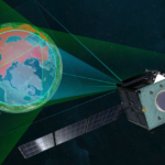
By B.C. Kessner

The Lockheed Martin [LMT] team designing GeoEye‘s [GEOY] next-generation, high-resolution imaging satellite, known as GeoEye-2, successfully completed the program’s Preliminary Design Review (PDR) three weeks ahead of the planned schedule, the company said recently.

“The steady pace at which we are progressing on GeoEye-2 is fully aligned with the cost, schedule and technical requirements established by our customer,” Allen Anderson, GeoEye-2 program manager for Lockheed Martin Space Systems Company, said in a statement. “We understand that achieving mission success on this program is imperative in a global environment that is significantly increasing its demands for geospatial information. We look forward to fielding GeoEye-2 at the earliest possible launch date.”

GeoEye-2 is slated for launched aboard an Atlas V rocket provided by Lockheed Martin’s Commercial Launch Services, and the satellite will be operational in early 2013, Lockheed Martin said.

The successful PDR completion validated the spacecraft’s design maturity, meeting or exceeding all GeoEye standards and program requirements. The team is now gearing up for the Critical Design Review (CDR) scheduled for early 2011, a key milestone that precedes the production phase of the program.

GeoEye in March selected Lockheed Martin to build the geospatial imagery for GeoEye-2.

ITT [ITT] built the imaging system for the GeoEye-1 satellite launched in Sept. 2008. ITT remains part of the GeoEye-2 team, providing a new high- resolution camera that has been in development since GeoEye contracted with ITT’s Geospatial Systems Division in October 2007.

Soon after the CDR, the team will start bus integration in the fall of 2011, a Lockheed Martin spokesperson told sister publication Defense Daily recently. Baseline Integrated System Test (BIST) and Thermal Vacuum (TVAC) tests will follow in mid-2012, paving the way for the early-2013 launch.

GeoEye-2 will feature several improvements in performance capabilities, such as enhanced tasking, the ability to collect more imagery at a faster rate, and higher ground resolutions than currently available commercially, the spokesperson said.

GeoEye was awarded a contract for the National Geospatial-Intelligence Agency’s (NGA) an EnhancedView program worth up to $3.8 billion on Aug. 6, 2010. The Lockheed Martin spokesperson said that financial terms for GeoEye-2 are not being disclosed at this time.

NGA was expected to pay a portion of the development of the next generation commercial satellite, as it did with a preceding program. Under the NextView contract, NGA paid about $500 million for half the cost of the development of GeoEye-1 as well as an 18-month commitment to buy imagery produced by the satellite.

NGA also paid about $500 million under a similar contract to DigitalGlobe for its WorldView-1 satellite.

Lockheed Martin and GeoEye have a long history having worked together on the world’s first commercial, high-resolution, Earth-imaging satellite, IKONOS. Lockheed Martin Space Systems designed and built IKONOS in 1999.

IKONOS continues to provide 0.82-meter ground resolution imagery to GeoEye’s customers around the globe, according to Lockheed Martin. These map-accurate images are used for applications in national security, environmental monitoring, state and local government, disaster assessment and relief, land management and for many other geospatial applications, the company added.

GeoEye-2 will have a 0.33-meter ground resolution at nadir–about 400 mile orbit–with four multispectral bands: Blue, Green, Red, and near infrared, the spokesperson said.

“This is an important milestone for our GeoEye-2 satellite program,” Bill Schuster, GeoEye’s chief operating officer, said in a statement. “We are very pleased Lockheed Martin is committed to meeting our stringent objectives and schedule.”

Schuster said worldwide commercial market demand is increasing, and that the U.S. government has growing requirements for large-area coverage at the best resolution commercially available. “We look forward to commissioning GeoEye-2, which will meet this increased demand and help sustain GeoEye’s strong growth rate when fully operational,” he added.

GeoEye-2 is designed to provide intelligence analysts, war fighters, and decision makers map-accurate images at an increased resolution, with a greater spacecraft response rate and level of performance reliability unmatched by existing spacecraft, Lockheed Martin said. Once fully operational, GeoEye-2 will be the highest resolution commercial satellite in the world.

Lockheed Martin Information Systems and Global Solutions rounds out the GeoEye-2 team, producing the ground control system.